Friday, December 6, 2013

Snow Hits Southwest Washington and Oregon and a Reverse Convergence Zone

As predicted by the models for several days, a low moved southward along the Northwest coast, bringing light snow to the coast and SW Washington and much heavier amounts to the western interior of Oregon.   A light dusting spread last night into the Kitsap Peninsula from Olympia southward. 

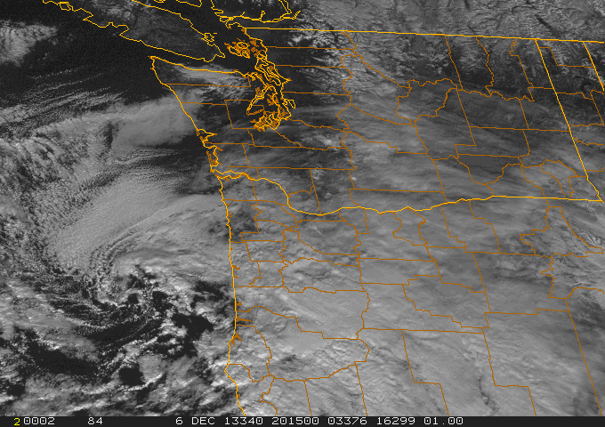
Here is the visible satellite around noon on Friday.  You can see the swirl of clouds associated with the low off of northern Oregon.

The amount of snow that has fallen across the region has varied substantially as of 12:30 PM.  Four inches were on the ground in Salem, Oregon at that time (6 inches at 4 PM) and I have an unofficial report of 9 inches near Corvallis, Oregon.   Take a look what Oregon State in Covallis looked like today:

 Here are a few cam shots on I5 near Eugene--this does not look like pleasant travel.

 The Washington Coast got around 1/2 inch as did some locations around SW Washington.

As the low moved south of Washington, easterly flow has increased over Washington State--thus air is approaching the Olympics through depth from an unusual direction...from the east.  A plot of the winds over Seattle shows this change clearly (time increases to the left, the y axis is pressure, red lines are temperature).  The atmosphere is cooling and the winds are easterly to 700 hPa (roughly 10,000 ft)

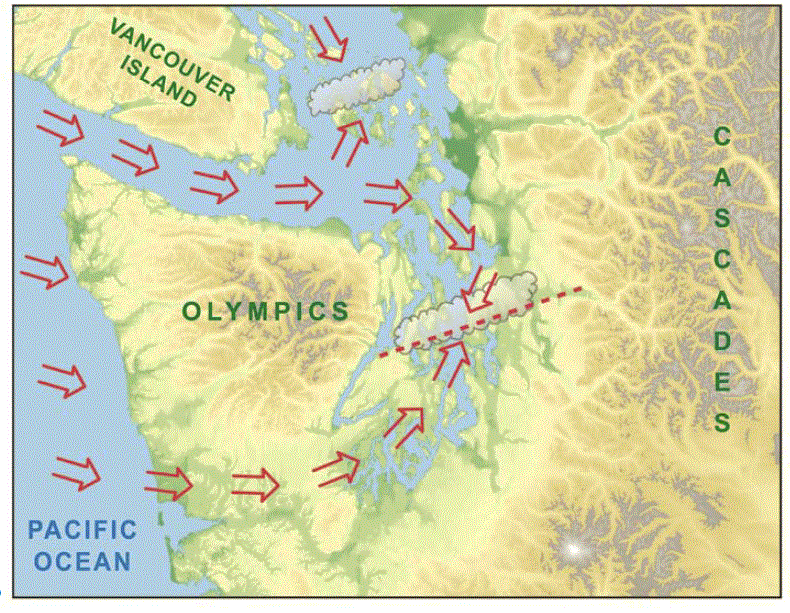
With easterly winds approaching the Olympics we are getting an interesting phenomenon...a convergence zone on the WESTERN side of the mountains, with an accompanying band of clouds and even some precipitation.  Many are familiar with the Puget Sound convergence zone, in which westerly winds approach the Olympics, move around the Olympics at low levels, and converge over Puget Sound producing a band of clouds and precipitation (see graphic).

Now reverse the winds and you get a convergence zone to the west of the Olympics.  

Let me prove it to you.  Here is a MODIS visible satellite picture at 12:10 PM Friday.  You see the band of clouds extending southwestward from the Olympics?...that's it.  There are also clouds north of the Olympics, produced by the NE flow coming out of the Fraser River gap and passing over Bellingham and the San Juans  before being forced to rise by the Olympics.  Perhaps some snow over south Port Angeles!

 We can get an even better view of the offshore convergence zone by viewing an image from the Langley Hill radar in Hoquiam (see below).  An amazing image...you can see a narrow plume of precipitation in the coastal convergence zone.

Today, our models are good enough to forecast such features. Here is an 8 hour forecast of clouds by the UW WRF (1.3 km resolution).   Both the coastal convergence zone and the upslope clouds south of Port Angeles is in there.  We have come a long way.

A model forecast of the winds  at 1 PM show the converging winds west of the Cascades.


The coldest temperatures are coming the next two nights...here is the forecast temperature at 7AM Saturday AM.  16-20F over many locations on the eastside of Puget Sound.  Single digits and negative temps in eastern WA.  Wind chills in the mountains will be brutal...below -20F will not be uncommon.  Be prepared if you go up there.


Question
Are you in venture capital/private equity and have an office in the Bay Area, or knows someone who does?
If so, I have a question for you. Please send me an email (cmass at uw.edu) ....thanks, cliff


Wednesday, December 4, 2013

Cold Facts and Coastal/Oregon Snow


We are now experiencing our coldest weather since January, with temperatures falling below zero in "favored" spots of eastern Washington and Oregon.  Snow is coming to the Northwest during the next two days, but unfortunately will miss most of Washington.

But first, this morning there was an unusual sight:  a line of clouds down the center of Puget Sound (see picture from the UW web cam facing the Olympics).  The cause?  The cold air!


Last night we had a land breeze on both sides of the Sound.  A land breeze occurs when the land is colder than the water, generally by at least 5-10F.   Last night that happened:  the water temperature is roughly 50F while the land temperatures dropped into the 20s.  Air from the cold land moves towards the water.   The land breezes on both sides of the Sound converged over the central Sound and rose, producing a line of clouds. You can see a hint of this from the winds taken over Puget Sound this morning by the Washington State ferry traveling between Edmonds and Kingston around 8:30 AM (see below)

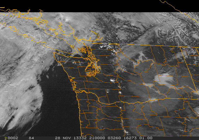
The next map shows you the low temperatures across the region last night.  Some of the coldest temperatures were at Pullman (-3F) and in the nearby Blue Mountains.  Why was it so much colder at Pullman than say Moses Lake?   The answer is found in a satellite image taken this morning:  Pullman had snow on the ground (see picture below).


Snow covered NW Oregon and SE Washington.  Snow is associated with cold temperatures:  it reflects the sun during the day and is a very effective emitter in the infrared.   And it can insulate the lower atmosphere from warm ground.


Now let's talk forecast.  An upper level trough is moving southward around the high, causing upward motion, clouds, and precipitation (see map at 10 PM Thursday at 500 hPa).  Associated with the

upper trough is a low center at and near the surface (see surface map).  
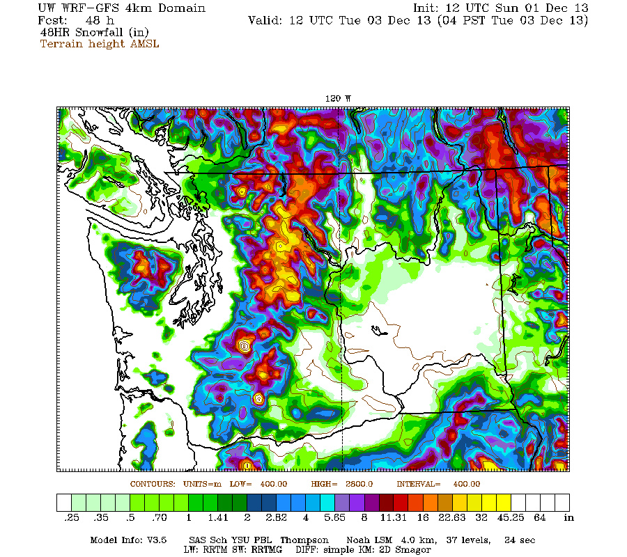
 The frustrating thing for snow lovers is that the low is passing too far offshore to bring snow to most of Washington, perhaps light snow on the WA coast and moderate snow over central and southern Oregon as the low swings eastward south of us.  If the low was one hundred miles to the east and Seattle would be white.  Here is the projected 48h snowfall ending Saturday at 4 AM.  Oregon is nearly COMPLETELY covered with snow, with the  exception of Portland and Columbia Gorge.  Northern CA gets snow.   Just not fair.

 Then you expect dry and cold conditions through the weekend.   One notable weather feature:  very strong winds are expected on Friday and Saturday downstream of the Fraser River Gap--we are talking Bellingham, San Juans, and the neighborhood.  Here are the gusts at 4 PM Friday.  50 kts over the Strait of Georgia from the NE and strong easterlies over the Pacific and Strait.

And expect windy conditions along the western slopes of the Cascades, particular in Enumclaw, Black Diamond, the Issaquah Highlands, and North Bend.

Announcement

Are you in venture capital/private equity and have an office in the Bay Area, or knows someone who does?
If so, I have a question for you. Please send me an email (cmass at uw.edu) ....thanks, cliff


Monday, December 2, 2013

Nowcast: No Snow Problems for Evening Commute or Seahawks Game

I have gotten a number of emails from folks worrying about snow during the commute and after the Seahawk's game in Seattle tonight.

There will be no problems during the commute tonight and I don't think driving home from the game will be much of an issue.  But don't be surprised if some snow flurries/dusting occurs around 9-10 PM or so.

Right now (4:45 PM), the SnowWatch web site shows that air temps around 40 and the road temps are in the mid-40s (see graphic)

Cold air has just started to push out of the Fraser Gap into Bellingham, where snow began at 4:42 PM.  It is very light and will take 4-5 hrs to reach Seattle.  The latest radar shows two major local bands of precipitation over the lowlands: a convergence zone band over Snohomish County and northern King County and a band south of Bellingham associated with the Fraser River outflow.  The latter band will move south in time.  It may rev up when it interacts with the convergence zone band, which should weaken in time.    Anyway, there should be a line of weak convective showers leading the northerlies that pushes southward into Puget Sound during the middle evening.


According to the Snowwatch temperature information, the freezing level was at around 2000 ft at 4 PM.   The snow level is about 1000 ft below that.  The air is cooling, so the snow level will probably get to around 500 ft by 10 PM.   So near sea level I would expect the precipitation to start as rain as the band comes through.  Over time, melting and evaporation could help bring some flakes to near sea level, but road surfaces will be warm.   And the snow will move through quickly.

Bottom line:  no real threat at sea level even if the worst scenario occurs.  So enjoy shopping or going to the Seahawks game...the weather won't stop you....


PS:  There are more chances of snow in our future!


Announcement

Are you in venture capital/private equity and have an office in the Bay Area, or knows someone who does?
If so, I have a question for you. Please send me an email (cmass at uw.edu) ....thanks, cliff

Sunday, December 1, 2013

Sunday Update: Amazing Rain Shadow and Snow Outlook

If you have lost your sun glasses, as many Northwesteners do during the winter, you better find them.  Bright sunshine and cold, crisp conditions are only 1-2 days away.  Cold air will be streaming over our region tomorrow, with only a few pesky snow showers in portions of western Washington.  I don't think there will be major problems with the Seahawks game on Monday night, unless the models are very wrong.

The big weather story today  is heavy rain and wind...but many of you are experiencing neither!  How is that possible?

Here is the precipitation over the past 24h (ending 11 AM Sunday) at a collection of NW stations.  Some folks to the east of the Olympics and Vancouver Island have gotten only a few hundredths of an inch, while the western slopes of the Cascades have received 2-3 inches (and will get more).

 Take a look at blow up of the 24 h totals.   ONE HUNDREDTH of an inch on Kitsap, while a few inches fell on the western Cascade foothills.


 Why this profound rain shadow in central Puget Sound?  The reason is that we have a strong trough embedded in northwesterly flow and the flow at crest level is westerly....producing a rain shadow to the lee (east) of the Olympics.

Here is the flow at 850 hPa (around 5000 ft and a good level to see what is approaching the mountains at crest level) at 8 AM.  VERY strong winds from the west to northwest (the winds are proportional to the gradient of heights shown by the solid lines.  The heights are like pressures on a surface chart.  Winds are parallel to the lines).  The air over us this morning is quite warm (denoted by red/orange colors in that chart)

 Warm enough that rain is falling in the passes (as shown below)...heavy rain at that.
 With a large north-south pressure difference and strong winds aloft, some locations, particularly in the south Sound and the Strait, have been buffeted by winds gusting about 40 mph (see graphic)


 Anyway, no issues for travel across the Cascades other than water ponding on the roadways and poor visibility.

      As I mentioned before, the cold air is coming on Monday.   The models are NOT producing major snowfall in the lowlands, but some of you will see some light white stuff.   As the cold air pushes out of the Fraser River gap on Monday AM, there could be some light snow at its leading edge over NW Washington (see map of 3-h snow ending 10 AM).

 As the cold air pushes south and west, some of it will be forced to rise by the Olympics, perhaps producing some light snow over Port Angeles and southern Sequim (see map for 3-h snow ending 1 PM)

During the next few hours Monday afternoon the cold air pushes south through Puget Sound.  The various models I have looked at are not producing much (see map below)...perhaps a few snow flurries.  If our models are wrong, this is when any snow would fall...Monday afternoon.

 Why are we not getting a big snowstorm in the lowland?  The set up is not correct.  The upper trough...and the upward motion associated with it...is sliding to the east too quickly, so there won't be good upward motion when the cold air pushes in.  Furthermore, the position of the trough is not good for setting up a strong convergence zone over Puget Sound when the cold air approaches.  The subtleties are important in snow forecasting in our area...everything needs to be just right to overcome the ocean's warmth.

The total predicted snowfall for the next 48-h is shown below.  The mountains should do some business on Monday, but the lowlands are mainly snow free.  Disappointing to kids.

Anyway, get those sunglasses and protect your hoses, pipes, plants, and animals from unaccustomed cold.

Announcement

Are you in venture capital/private equity and have an office in the Bay Area, or knows someone who does?
If so, I have a question for you. Please send me an email (cmass at uw.edu) ....thanks, cliff

Saturday, November 30, 2013

Heavy Rain, Flooding, Mountain Snow, Cold, and Wind: Mother Nature's Revenge on the Northwest

During the next few days the Northwest is about to experience everything mother nature can throw at us:   heavy rain, river flooding, a good snow dump in the mountains, unusual cold, gusty winds, and perhaps..yes perhaps...a light dusting of snow in a few lowland locations of western Washington.

What's not to like?  Snow will not impede holiday travel on Sunday, but heavy rain in the passes and on the Cascade western slopes might make for some tedious driving.

The media, and some of us meteorologists, have been focused too much on snow and cold..  Mother nature is like a magician:  keeps us watching the wrong thing, while the real story (heavy rain and flooding), always in the open, is ignored.

Today, Saturday, will be uneventful with clouds and a bit of light rain.  Perfect for shopping or reading a good book.  But on early Sunday the real action will begin, moderate to heavy rains, particularly over the western Cascade slopes.   Here is the precipitation forecast for the 24-h ending 4 AM on Monday.  VERY heavy rain on the western slopes of the central and southern Cascades, reaching  5-10 inches.

This is not your typical pineapple express/atmospheric river with the moisture coming from the southwest..instead high water vapor values will move northward in the mid-Pacific and head directly into us from the west (see graphic for Sunday at 4 PM). With the moisture and winds at crest level from the west-southwest, there will be considerable rain shadowing over the northwestern Sound (see map above)

The heavy rain will cause the rivers to rapidly rise, with some reaching flood stage.  Take a look at the current forecast from the NWS River Forecast Center for the Snoqualmie near Carnation.  This is a major flood.

And the river forecast center is predicting high water levels on a number of western Washington rivers draining the western slopes of the Cascades (see graphic)
On Sunday there will be a large north-south pressure gradient and thus the winds will pick up substantially from the south. particularly Sunday AM.  Here are the sustained wind forecasts for 8 AM on Sunday.  Strong winds in the Strait (35 knots) and over central and southern Puget Sound (25 knots).  The gusts will be stronger. With most leaves down and pruning from previous windstorms, I don't expect a large number of power outages.


 So we covered heavy rain, flooding, and strong winds--and are just starting here!

The cold front will reach the northern WA coast during the morning and push through during the day. The surface forecast map at 4 PM shows the front reaching the southern WA coast...and note there will be strong southerly winds along the Oregon coast at that time.   The primo cold air has not reached us yet.
During the next 24 hour cold air floods in behind the cold front and from air pushing south from BC.  Here is the same surface map a day later...wow...a different world.  The cold front has reached the Oregon/CA border and truly cold arctic air (purple) is now in southern BC.  Northeasterly winds are now pushing through the Fraser River gap into Bellingham and the San Juans.

 The atmosphere will be cold enough to snow and substantial snow will fall in the mountains between late Sunday and Tuesday morning.  Here is the plot of 48-h snow totals ending 4 PM on Monday.  Some locations in the north Cascades will get nearly three feet.  Much less in the south Cascades (up to about a foot).  Mt. Baker will have wonderful skiing I am sure.
Lowland snow?  The big question for local media, and a lot of folks are nervous about the famous snow/ice situation at the end of the November 26, 2006 Seahawks game, where some people had to walk home.

 Nov. 26, 2006 Seahawks Game


Quite honestly this is not an idea set up for significant lowland snow...but we will have cold enough air by mid-day Monday.  There will not be a general lowland snow event.  But there are three possibilities of some light localized snow later on Monday and Tuesday AM: in a Puget Sound convergence zone, at the leading edge of the northerlies coming out of the Fraser Gap, or upslope on the NE side of the Olympics.  The models are not going for much, but we need to watch it.

We will have very cold temperatures next week..the coldest in two years (last winter was very wimpy in all ways).   Lows in the mid-20s will be everywhere west of the Cascade crest, with colder spots getting into upper teens.  You don't even want to know about eastern Washington (single digits!).

I tell my students that we can get lowland snow when the cold air comes in and when it leaves.  Guess what?  The current models suggest a significant snow event for portions of western Washington on Saturday.   Will give the media something to hype about this week!

http://www.youtube.com/watch?v=RW19m7muLaA
He is getting ready.... (click on image for the video)


Announcements

Are you in venture capital/private equity and have an office in the Bay Area, or knows someone who does?

If so, I have a question for you. Please send me an email (cmass at uw.edu) ....thanks, cliff


Thursday, November 28, 2013

Thanksgiving Saved But Arctic Air Looms

Friday Morning Update:  There will be no snow over the lowlands on Sunday and even the passes should be fine through the early evening.  

The big threat for lowland snow...if it occurs...is late Monday afternoon/Monday evening...more in a future blog.

Worried about travel on Sunday?  Heard stories about lowland snow snarling traffic or massive snow crippling the passes?  Don't worry about it...the latest models are far more benign for Sunday.

But another threat looms--very cold air will move into the region on Monday and stick around for much of the week.   Cold enough to burst your outdoor hoses, mess up irrigation systems, and do other mischief.

So let's see what is in the meteorological cards, now that we are closer to the cold-wave ground zero.

Thanksgiving Day has been as good as it gets.  Clear skies over most of the region, will some fog over Puget Sound and a few valleys (see satellite picture).  This time of the year you have a choice:  wet and windy or dry, cold and foggy.

A strong inversion is above us now, with hilltop locations in the mid-50s and bright sun.  Remember this is the stormiest and windiest week of the year climatologically.   Clearly, the combination of Chanukah and Thanksgiving has had a magical effect.

Friday and Saturday will be Northwest blah.  Clouds, a few sprinkles, highs near 50F.  Good shopping weather.

Sunday is a different story.  The latest runs bring a strong trough in from the Northwest, but the timing is about 12-h later than a few days ago...and that makes all the difference. And the movement of the trough is not optimal for lowland snow (too easterly motion).  Here is the forecast upper level (500 hPA) chart for Sunday at 10 AM.  Impressive trough and low to our northwest.

But we are still in SW flow at this time, so the air is still quite warm.  With a trough like that expect rain...and I mean heavy rain...including lower elevations in the mountains.  Below is the precipitation forecast for the 24h period ending 4 PM on Sunday.   Big amounts, with up to 5-10 inches over the lower slopes of the Cascades.  The winds will have a strong westerly component and there is a strong rain shadow to the east of the Olympics, stretching towards north Seattle.   Those spoiled folks in Sequim will be wetter than those of us in Seattle!  Give you a warm feeling.

And did I mention the wind?  On Sunday afternoon, a strong cold front will be approaching our coast and there will be strong southerly winds (20-30 mph sustained) in front of it.  You can see the front on the surface forecast map for 1 PM on Sunday (lines are isobars of constant pressure, colors indicate lower atmosphere temperatures..blue/white are cold).
The bottom line is that Sunday will be wet and windy, but no snow messing up driving.  And the passes should be ok:  the major snowfall there will occur AFTER the front passes around 6-8 PM.  Don't wait until 10 PM or later to cross.  You might be sorry if you do.

On Monday, modified arctic air will move in to the Northwest (see surface map at 1 PM Monday.  At this point it will be cold enough to snow in the Washington lowlands north of Olympia, but will there be any precipitation at this time?  The current model runs don't show much, but we need to be careful.  In a residual convergence zone, or the leading edge of northeasterly air moving out of the Fraser Valley (into Bellingham and the San Juan's) there could be some snow showers.  Don't be shocked if you see some.  But right now, no significant lowland snow threat.

And by Tuesday at 10 AM, the air over us will be frigid...the coldest we have seen in a while.  Eastern Washington, particularly along the eastern slopes, will be particularly cold and windy.  By this time the Northwest will be dry.

Wednesday at 10 AM, even colder!
We are talking about minimum temperatures over the western Washington/Oregon lowlands in the 20s and upper teens, and lower teens/single digits in eastern Washington.

You got hoses attached on the outside of your home or apartment?  Disconnect them and drain the water.  Drain irrigation systems and bring in hummingbird feeders at night. 
You don't want this!

Regarding mountain snows, here is the current forecast 48h total ending 4 AM on Tuesday.  1-2 feet in the higher Cascades, less than a foot in Snoqualmie.  A nice refresh for the mountains, but not as much as predicted a few days ago.

Finally, here is the last NOAA/NWS Climate Prediction Center 6-10 day temperature forecast for the U.S.  All I can say is WOW.  Very certain of much colder than normal temperatures (the dark purple colors) over much of the western U.S.


Anyway, there is much more I could talk about...like the strong NE winds over NW Washington or the potential for localized snow on the NE side of the Olympics.  But I have serious cooking duties right now and want to drain my outdoor pipes in the pleasant Thanksgiving weather.

Happy Chanukah and Thanksgiving.