The reason? There is cold air and higher pressure in eastern Washington and lower pressure west of the Cascade crest (see forecast map for 10 AM Saturday AM to see this). Big pressure difference along the crest, with a 10 hPa (mb) difference between Seattle and Yakima. Air loves to accelerate from high to low pressure in terrain gaps, producing very strong winds on the western side of the Columbia Gorge.
Consider the winds at one of my favorite locations, Vista House, position above the Gorge at Crown Point (see picture).
Here are the winds there today at Vista House. Sustained 40 mph with gusts reaching over 77 mph earlier today. That would get your attention!
And here are the max winds observed around the western Gorge for the past 24 h (ending 1 PM Saturday). Very strong winds on a hilltop on the opposite side of the Gorge (61 mph) and even Troutdale and nearby locations had gusts about 40 mph.
Now I have a treat for you. We can secure wind observations from jets landing and taking off from Portland Airport. Here is what the planes observed for the 24 hr ending roughly 10 AM this morning. (Keep in mind that time is along bottom axis...later to the left...and height in pressure is the ordinate...850 hPa is about 5000 ft. Temperature is shown in red.) There are strong easterly winds (30-35 knots) in the bottom few thousand feet. But go above 5000 ft and winds become light. Classic for gap flow.
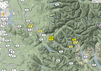
And we have some of the gap flow fun around Seattle too, but the effects are not as profound because our gaps are just a lowering in the height of the Cascade crest, not a sea-level gap as exists in the Columbia Gorge. Here are the max 24h winds for the last day. Roughly 40 mph gust at Alpental and east of North Bend, with some winds extending to Snoqualmie and Preston.
The extraordinarily fine late November weather will continue the next week. Really, it is a gift to get such a dry, sunny period this time of the year. Here is the forecast rainfall over the next 72h. Oregon and Washington will get nearly nothing, with the exception of a passing blow to the NW coast.
But you surely want to know about Thanksgiving, since many of you will be on the road that day or enjoy a walk to prepare for the big meal. Here is the rainfall forecast for the 24-h period ending 4 AM on Friday. Dry for us and WET over California. If you live down there, making sure the heater
is working on your hot tub....you will need it.
Because of the weather next week, Californians will need some very large heaters for their hot tubs.


No comments:
Post a Comment