Friday Morning Update: There will be no snow over the lowlands on Sunday and even the passes should be fine through the early evening. The big threat for lowland snow...if it occurs...is late Monday afternoon/Monday evening...more in a future blog. Worried about travel on Sunday? Heard stories about lowland snow snarling traffic or massive snow crippling the passes? Don't worry about it...the latest models are far more benign for Sunday.
But another threat looms--very cold air will move into the region on Monday and stick around for much of the week. Cold enough to burst your outdoor hoses, mess up irrigation systems, and do other mischief.
So let's see what is in the meteorological cards, now that we are closer to the cold-wave ground zero.
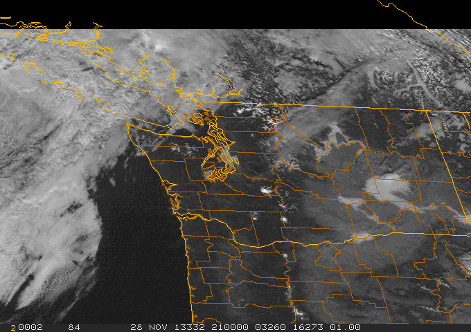
Thanksgiving Day has been as good as it gets. Clear skies over most of the region, will some fog over Puget Sound and a few valleys (see satellite picture). This time of the year you have a choice: wet and windy or dry, cold and foggy.
A strong inversion is above us now, with hilltop locations in the mid-50s and bright sun.
Remember this is the stormiest and windiest week of the year climatologically. Clearly, the combination of Chanukah and Thanksgiving has had a magical effect.
Friday and Saturday will be Northwest blah. Clouds, a few sprinkles, highs near 50F. Good shopping weather.
Sunday is a different story. The latest runs bring a strong trough in from the Northwest, but the timing is about 12-h later than a few days ago...and that makes all the difference. And the movement of the trough is not optimal for lowland snow (too easterly motion). Here is the forecast upper level (500 hPA) chart for Sunday at 10 AM. Impressive trough and low to our northwest.
But we are still in SW flow at this time, so the air is still quite warm. With a trough like that expect rain...and I mean heavy rain...including lower elevations in the mountains. Below is the precipitation forecast for the 24h period ending 4 PM on Sunday. Big amounts, with up to 5-10 inches over the lower slopes of the Cascades. The winds will have a strong westerly component and there is a strong rain shadow to the east of the Olympics, stretching towards north Seattle. Those spoiled folks in Sequim will be wetter than those of us in Seattle! Give you a warm feeling.
And did I mention the wind? On Sunday afternoon, a strong cold front will be approaching our coast and there will be strong southerly winds (20-30 mph sustained) in front of it. You can see the front on the surface forecast map for 1 PM on Sunday (lines are isobars of constant pressure, colors indicate lower atmosphere temperatures..blue/white are cold).
The bottom line is that Sunday will be wet and windy, but no snow messing up driving. And the passes should be ok: the major snowfall there will occur AFTER the front passes around 6-8 PM. Don't wait until 10 PM or later to cross. You might be sorry if you do.
On Monday, modified arctic air will move in to the Northwest (see surface map at 1 PM Monday. At this point it will be cold enough to snow in the Washington lowlands north of Olympia, but will there be any precipitation at this time? The current model runs don't show much, but we need to be careful. In a residual convergence zone, or the leading edge of northeasterly air moving out of the Fraser Valley (into Bellingham and the San Juan's) there could be some snow showers. Don't be shocked if you see some. But right now, no significant lowland snow threat.
And by Tuesday at 10 AM, the air over us will be frigid...the coldest we have seen in a while. Eastern Washington, particularly along the eastern slopes, will be particularly cold and windy. By this time the Northwest will be dry.
Wednesday at 10 AM, even colder!
We are talking about minimum temperatures over the western Washington/Oregon lowlands in the 20s and upper teens, and lower teens/single digits in eastern Washington.
You got hoses attached on the outside of your home or apartment? Disconnect them and drain the water. Drain irrigation systems and bring in hummingbird feeders at night.
You don't want this!
Regarding mountain snows, here is the current forecast 48h total ending 4 AM on Tuesday. 1-2 feet in the higher Cascades, less than a foot in Snoqualmie. A nice refresh for the mountains, but not as much as predicted a few days ago.
Finally, here is the last NOAA/NWS Climate Prediction Center 6-10 day temperature forecast for the U.S. All I can say is WOW. Very certain of much colder than normal temperatures (the dark purple colors) over much of the western U.S.
Anyway, there is much more I could talk about...like the strong NE winds over NW Washington or the potential for localized snow on the NE side of the Olympics. But I have serious cooking duties right now and want to drain my outdoor pipes in the pleasant Thanksgiving weather.
Happy Chanukah and Thanksgiving.


No comments:
Post a Comment