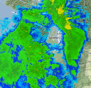
Friday was a day of contrasts: while the windward side of the Olympics were being slammed with several inches of precipitation at lower elevations with lots of snow aloft, it was nearly dry over parts of Kitsap County and Seattle. Hard to believe, but true! I biked to and from the UW Friday and did not feel a single drop. However, strong, gusty winds almost blew me off the Burke Gilman trail on my way home.
Let's start with the 24-h precipitation totals ending 9 PM on Friday (see below). A few hundredths of an inch over central Puget Sound, while a few dozen miles to the east along the western Cascade slopes some locations got more than 3 inches. The origin? A rain shadow in the lee of the Olympic Mountains. If you look carefully you will see very light precipitation to the east of the mountains of Vancouver Island, which has its own rain shadow.
The radar-based precipitation for the same 24 hours from the Seattle RainWatch web site also clearly shows the rain shadow (see graphic)
As does a radar snapshot at around 3 PM Friday afternoon:
The reason for this profound rain shadow to the east of the Olympics? We have quite strong westerly flow over us, flow that was associated with a disturbance originating in the Gulf of Alaska. To illustrate, here are the winds, temperatures, and heights of the 850 hPa pressure surface (about 5000 ft above the surface). 30-40 knot westerly to west-northwesterly flow hitting the Olympics. Where the winds take air upwards, you get enhanced precipitation. Where the air is rapidly descending (east of the Olympics), precipitation is attenuated.
The air still has water vapor in it even when precipitation is not falling; as the air is forced again to rise (this time by the Cascade), torrential rain and snow results.
High-resolution model forecasts knew such rain shadowing was coming. Here is the precipitation forecast made on Thursday afternoon for the 24h precipitation ending 4 AM on Saturday by the UW WRF model. Not perfect, but the essential pattern is there.
Very strong winds has moved into the Strait of Juan de Fuca late Friday behind the passing trough, with gusts to 50-60 miles per hour. Here are the max winds for the 24-h ending 9 PM Friday. Western Whidbey is being hit hard.


No comments:
Post a Comment